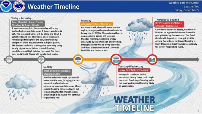
Seattle, WA — The National Weather Service (NWS) in Seattle is forecasting a very wet and active weather pattern across the Pacific Northwest over the coming week, bringing widespread rain, mountain snow, rising rivers, and the potential for flooding in several areas.
According to NWS, the unsettled weather began Friday with rain, mountain snow, and gusty winds, accompanied by minor coastal flooding near high tide. Rivers started to rise as runoff increased across the region.
Timeline of Expected Weather Impacts
-
Saturday: Additional rain, breezy winds, and snow at higher elevations continue. Minor coastal flooding and urban drainage issues remain possible. Rivers are expected to keep rising.
-
Sunday: Another weak weather system brings renewed rain and mountain snow. While coastal flooding risks decrease slightly, rivers will continue a gradual rise, especially along interior waterways.
-
Monday: A stronger atmospheric river is expected to move into the region, delivering widespread moderate to heavy rain and increased mountain snow. NWS warns of elevated landslide and burn-scar risk as saturated ground conditions worsen.
-
Tuesday–Wednesday: The peak of the event is expected with heavy rain and river flooding likely, particularly on Wednesday when rivers across multiple basins could exceed flood stage.
-
Thursday and Beyond: Gradual improvement is expected, but river flooding may continue, especially for slower-responding river systems.
Public Safety Advisory
Officials urge residents to stay alert for flood advisories, road closures, and landslide-prone areas, particularly near steep slopes and burn scars. Drivers are advised to use caution during periods of heavy rain and avoid crossing flooded roadways.
The National Weather Service will continue to issue updates as the storm system evolves.
⚠️ Very wet and active weather is settling into the Pacific Northwest over the next week. Here’s what you can expect: #WAwx pic.twitter.com/zWqzgFqE2V
— NWS Seattle (@NWSSeattle) December 5, 2025

